Showing posts with label Apache. Show all posts

Sunday, April 24, 2016

Wagon Mound...Wagon Mound, New Mexico


DATE:  04/01/2016

HISTORICAL SITE:  Wagon Mound
LOCATION:  East of Wagon Mound on U.S. 85, Mora County, New Mexico

MARKER #:  66000478

DEDICATED:  October 10, 1966
“This last great landmark on the Santa Fe Trail was named for its resemblance to the top of a covered wagon. At Wagon Mound, travelers could cross from the Cimarron Cutoff to Fort Union, which is located on the Mountain Branch of the Trail. The two branches joined south of here at Watrous.”

PERSONAL REFLECTIONS: 

Traveling north on I-25 from Santa Fe, there really isn’t a lot to look at. The landscape, a glimpse of what was to come for several days, was mainly open grassland.  As I promised myself during my very first trip, my gas gauge showed a quarter tank so it was time to start looking for a gas station. Then here comes this tiny little town called Wagon Mound and, oh, good…gas. In fact, it’s not even legally a “town”  but rather a “village”.

The village of Wagon Mound used to be quite prosperous and then the interstate was put in and traffic just sped by…not unlike the story of Route 66.

In 1900, the town boasted it had 4 saloons, a bank, a livery barn, 3 bakeries, 2 grocery stores, 2 hotels, 2 blacksmith shops, 2 restaurants, and a weekly newspaper in both English and Spanish.

The main line of the Atchison, Topeka and Santa Fe Railway went right through the town.

Pulling off the freeway, we see a sign for a historic site…bonus. So, we fill our tank and then come back to the marker.

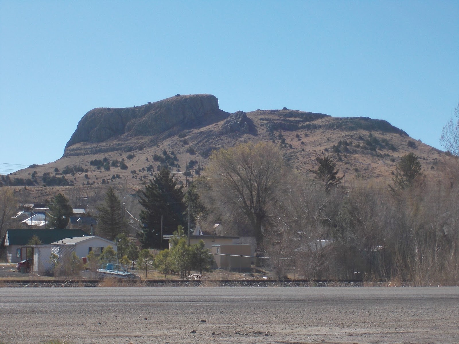
Wagon Mound, a large hill near the town, so named because it looks like the top of a covered wagon is considered the “last great natural landmark on the Santa Fe Trail” and can be seen at least 60 miles from the North and East.

The Santa Fe Trail, which Wagon Mound is a part of, was one of America’s great trading routes. A total of 1,200 miles from Franklin, Missouri to Santa Fe, New Mexico, it was a vital trail for trading, the military and emigrants from 1821 to 1880.

The trail had many Way Stations, Trading Posts and military Forts.

Even after the territory was ceded by Mexico after the war, trade between Mexico, south of the trail, and the United States flourished for many years.

All along the trail, travelers used natural landscape features to help them navigate. Places like Pawnee Rock, Rabbit Ears Mountain and Wagon Mound aided the travelers.

As you can imagine, Wagon Mound, being 6,930 feet high, and resembling oxen pulling a wagon, was very easy to see. Care needed to be taken to recognize this site as the area was the Cimarron Cutoff point to Fort Union.

The area quickly became a favored spot for travelers to rest. The abundance of green grass and water was appealing, yet just 2 miles north, the Santa Clara Spring camping spot became the site of many Indian ambushes.

The mound was not only a navigational tool and a promise of a good rest, but became a warning to travelers about the local Indians.

As the number of travelers grew, the relationship with the Indians got worse as their traditional way of life was interrupted more and more. This area had been home to many major tribes including Comanche, Kiowa, Cheyenne, Arapaho, Plains Apache, Osage, Kansas (Kaw), Apache, Ute, and Pueblo Indian.

The U.S. Government, along with Mexico, started providing escorts on the trail further enraging the Indians until the “Mail Train Massacre” in May of 1850 where a mail train going west was attacked and all 10 men were killed. The bodies weren’t found for a couple of weeks until the eastern mail train came upon them.

It was estimated there were over 100 Indians and up until this point, a train with 10 men were considered safe. The Government increased its raids and attacks against the Indians; resulting in the Indian population being pushed back and onto reservations.

During the civil war, with the U.S. Army engaged elsewhere, the cutoff was considered too dangerous with Confederate raiders and Indians so traffic basically stopped until the war was over.

And once the railroad made its way through the area, the trail, given time, was abandoned for the new transportation option.

Saturday, July 25, 2015

The Petrified Forest & Painted Desert - Apache & Navajo Co., Arizona


DATE:  July 6, 2015

HISTORICAL SITE:  Petrified Forest National Park

LOCATION:  Apache & Navajo Co., Arizona

MARKER #:  75000217 & 76000185 & 87001421 & 05000284

DEDICATED:  October 10, 1975 & July 12, 1976 & May 28, 1987 & April 15, 2005

"This property has been listed in the National Register of Historic Places by the United States Department of the Interior   1976   Newspaper Rock Petroglyphs Archaeological District"

"Painted Desert Inn has been designated a National Historic Landmark   This site possesses National significance in commemorating the history of the United States of America   1987   National Park Service   United States Department of the Interior"

"This property has been listed in the National Register of Historic Places by the United States Department of the Interior   2005   Painted Desert Community Complex Historic District"

MARKER PLACED BY:  National Park Service, United States Department of the Interior


PERSONAL REFLECTIONS: 

I was surprised to find out that although Dirk was born and raised in Arizona, he has never visited the Petrified Forest or Painted Desert. I remember my parents taking us as little girls and for some reason that has stuck with me and is the driving force behind my desire to see this area again.
While not as breathtaking as the Grand Canyon, you can see similarities and this place can still stop you in your tracks with its beauty.

At one point, Dirk and I were just standing and looking. We'd said all the oooh's and ahhh's and were quiet. I looked over at Dirk and he had this look on his face I have seen before and am in awe of. I'm not sure how to describe it other than to say it is joy and the quietness of a soul...if that makes sense. He then looked at me and said "God did good".

While it's officially the Petrified Forest National Park, the northern end extends into the Painted Desert and is known for fossilized trees from the late Triassic period, about 225 million years ago.

In the late 1800's, concern grew over the number of tourists visiting and removing artifacts. Arizona asked the U.S. government to create a Petrified Forest National Park.

Like the Grand Canyon, the journey to national park wasn't easy and like the Grand Canyon, Roosevelt had to use the Antiquities Act of 1906 to create the Petrified Forest National Monument in 1932 and finally it became a National Park in 1962. Several successive presidents have signed legislation to acquire additional land where the size is currently 218,533 acres.

As part of the super continent of Pangaea, this area was near the equator and had a sub-tropical climate.

Paleontologists have been working in the park since the early 20th century, finding Triassic plants, but also giant crocodile like reptiles called phytosaurs, large salamander like amphibians called Buettneria and early dinosaurs.

It is the same sediments that buried the tree's so they could fossilize, that has caused the Painted Desert is be so colorful and that sediment is estimated to be up to 800 feet deep.

There have been nine species of fossil trees identified here...all extinct. Driving through the park, you can see remnants of the tree's all over the place, some denser than others.

The sediment is also easily weathered giving the landscape its cliffs, gullies and rounded hills.

The earliest humans arrived at least 8,000 years ago. Mostly nomadic until about 2,000 years ago when humans built pueblos and were growing corn here.

As the climate changed, people moved out but more than 600 sites have been found to be archaeologically significant, including the petroglyphs site called Newspaper Rock.

The Hopi nation call it "Tutuveni" and the petroglyphs show the history of the Hopi Indian tribe carved into stone. The area contains about 5,000 petroglyphs estimated to be between 650 and 2,000 years old.

In 2008, Newspaper Rock was included on the Worlds Monument Watch List of endangered cultural sites. Sadly, along with the ancient petroglyphs is the graffiti of today. $100,000.00 later, the site is surrounded by a chain link fence and monitored by hidden cameras.
 
Until the 16th century, the only inhabitants were indigenous people. Then the Spaniards discovered this area while exploring Mexico and the southwest.

The first U.S. survey was in 1853, made by American explorers looking for good east to west routes. Soon a wagon trail was "built"...is that the right word? What do you call it..."carved" a wagon trail?

Homesteaders settled in the area and their cattle grazed within the borders of the park until the mid-20th century. Next came the railroad and finally, constant car traffic on Route 66 and now Interstate 40.

There are 3 sites designated as historical, the main complex, the petroglyphs and finally...the Painted Desert Inn.

Back in the 1920's, Herbert Lore built a tourist shop, lunch counter and trading post on the Kachina rim. In 1932, the U.S. government proclaimed the Painted Desert a national monument. Lore negotiated $59,400.00 out of the U.S. government for his land and building. $60k in 1932? Not bad at all.

The original inn was built using the petrified wood from the park and was called Stone Tree House. Using the parks natural resources was a bit frowned upon so they rebuilt the inn; that being completed by the Conservation Corps in 1937.

Ok, this is strange to me but they didn't want to use the parks resources that were ALREADY being used so they tear it down and use other natural resources. Maybe less scarce but I bet that petrified wood was going to last forever.

Hopi artist Fred Kabotie was hired to paint scenes of everyday Hopi life and ceremonies on the walls of the Inn. 
There was a bit more remodeling right after the war and it was used as a railway hotel from 1947 to 1963 and finally destruction was discussed in the mid-70's.

Thankfully, cooler heads prevailed and after major renovations, the inn reopened in 2006 as a museum. You walk through the building and can appreciate the craftsmanship and the painting, but then you look up and there is a beautiful stained glass ceiling.


I'm really glad we got the opportunity to see one of the U.S.'s beautiful National Park.

Monday, June 15, 2015

The American International Rattlesnake Museum - Albuquerque, New Mexico


DATE VISITED:  04/28/2015

SITE:  American International Rattlesnake Museum 
 

LOCATION:  202 San Felipe St. NW, Albuquerque, Bernalillo Co., New Mexico 

PERSONAL REFLECTIONS: 

Snakes have always held a strange fascination for me. It’s one of those things where I’m scared but also so interested I normally will go out of my way to see them. While I love the reptile house at zoos, it’s not like I want to walk into a room to face a snake.

When Daniel appeared to become allergic to pet dander, we had to consider other “pets” and a snake was the easy choice. We ended up with a Corn Snake. When we got it, I had told the pet store I didn’t want anything that would grow taller than me. At last check “Nake” was about 3 inches taller than me.

I remember when a name was being considered. David wanted the name “Viper” and as I wandered through the room, I said the snake would probably end up being called “Nake” because Danny couldn’t really say his “S’s” yet. And sure enough…the name stuck.

This picture doesn't do justice but Nake grew to be a beautiful orange. If you’ve never touched a snake, you might be surprised to find they are incredibly soft. I love touching Nake…as long as someone is facing his head away from me. I’ve seen him bite the hand…and tummy…of the one that feeds him. Comical as it was listening to the “ouch, ouch, ouch”…I certainly never want to experience it myself.

I was quite excited to go to the National Rattlesnake Museum which was the opposite of Dana although she definitely warmed up to the place and was even sending SnapChats to her family.

The museum claims to have more live rattlesnakes, combined, than 6 of the largest zoos in the U.S. and have 30 or so out of the 100 on exhibit at all times with a plan on expanding soon.

The entrance fee of $5.00 is well worth what you will see during your visit. Their front area, with gift shop, doesn’t give you a clue as to how extensive the collection and exhibits are.

Rattlesnakes are native to the Americas with a majority of the species living in the American Southwest and Mexico while four are found east of the Mississippi and two in South America

It is believed that the ancestral area for the rattlesnake is probably in the Sierra Madre Occidental area of Mexico, a mountainous area in western Mexico.

While many snakes and other reptiles are oviparous (lays eggs), the rattlesnake is ovoviviparous (gives birth to live young after carrying eggs inside).

We all know that snakes can hibernate but I found out they can also “aestivate”.  Hibernation is basically going dormant if the temperature gets too cold. Aestivation is the opposite…going dormant when the temperature is too hot.
Humans experience about 8,000 bites from venomous snakes and rattlesnakes are the leading cause of snakebite injuries in North America. That being said, less than 1% result in death.

Antivenom is developed by “milking” rattlesnakes and injecting the venom into horses, sheep or goats who naturally produce antibodies. The red blood cells are separated and the serum is made into a powder to be used later by humans. Because it comes from animal antibodies, humans generally display an allergic reaction during the infusion.

While their museum is devoted mainly to rattlesnakes, they did have a couple of other interesting residents…

I had never seen anything like this…an alligator snapping turtle but but when I started asking around, lots of people grew up with them.

They are mainly in the Southeastern U.S. but can also be found in Kansas, Indiana, Missouri, Iowa, Kentucky and as far north as South Dakota. All I know is that I never want to run into one.
They will eat just about anything they can get their mouths on. When younger, they tend to hang around on the bottom with their mouths hanging open and their tongues hanging loosly…their tongues look like little worms and so entice fish to come closer.

They can bite hard enough to amputate fingers and after being found in the Czech Republic and Germany, are on the EU’s list of invasive species.

Some of their reptiles have names, like “Mollie”, the resident Gila Monster.

Gila Monsters are only 1 of 2 venomous lizards in the entire world and these are native to the Southwestern U.S. and the Mexican state of Sonora

The Apache and Pima believed Gila Monsters could kill or cause sickness while the Seri and Yaqui believed the skin had healing properties.

But one undisputed fact is that they are so slow, they are rarely dangerous to humans. In fact, a Dr. Ward wrote in 1899 that “I have never been called to attend a case of Gila Monster bite and I don’t want to be. I think a man fool enough to get bitten by a Gila Monster ought to die. The creature is so sluggish and slow of movement that the victim of its bite is compelled to help largely in order to get bitten”

“Marilyn” is an albino Western Diamond Back Rattlesnake. Albino’s normally don’t last long in the wild as they definitely stand out and easily become prey.


A normal colored Western Diamond Back Rattlesnake


A Paniment Speckled Rattlesnake that calls Nevada & California home.


I wish they showed this snake on their website as I would love to know exactly what it was. What I do remember was that it is definitely not an albino.


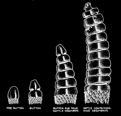
Rattlesnakes are born with a tail called “pre-button” but within 7 days of birth they have their first shedding and then it becomes the “button”. After that, each shedding, will add another “rattle”. The noise (listen here) is made when one rattle vibrates against another.


Dana and I were given “certificates of bravery” for completing a tour of the museum. It was very interesting and well work the visit.