Showing posts with label Abraham Lincoln. Show all posts

Thursday, November 12, 2015

Mt. Rushmore "Shrine of Democracy"...Keystone, South Dakota


DATE:  October 7, 2015

HISTORICAL SITE:  Mount Rushmore (Shrine of Democracy)

LOCATION:  13000 SD-244, Keystone, Pennington Co., South Dakota  57751

MARKER #:  66000718

DEDICATED:  October 15, 1966

PERSONAL REFLECTIONS: 

Not quite as breathtaking as the Grand Canyon or the Painted Desert, Mt. Rushmore is still a sight to see. I can write all kinds of adjectives to describe the size and undertaking this must have been but it’s one of those things you need to see for yourself. Where the Grand Canyon’s beauty lies in its creation, no matter how you felt that happened, the grandeur of Mt. Rushmore is man’s determination to leave a lasting memorial to a great nation.

The mountain was known by its Native American name “Six Grandfathers” and was part of the Lakota Nation. After the Great Sioux War of 1876, the U.S. seized lands given to the Lakota in perpetuity as part of the Treaty of Fort Laramie in 1868. The mountain was renamed Mt. Rushmore after Charles E. Rushmore led an expedition to the area in 1885.

A state historian of South Dakota, Doane Robinson, came up with the idea of carving in the mountains. He knew it would bring tourists…and dollars…to the area. He contacted a sculptor who was unavailable. Robinson knew of Gutzon Borglum but he was currently working in Georgia on a monument to General Lee. Borglum was in a dispute with the developers and when Robinson approached him, he eagerly signed on.
 
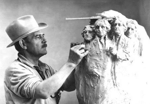
On board with the project, there was disagreement between Robinson who wanted something that represented the west (Lewis & Clark, Buffalo Bill Cody, Red Cloud), while Borglum felt it should be something more on a national level.

Borglum wanted the memorial to speak to the “spirit and ideals of American geographical expansion and political development”. The two almost immediately agreed upon Washington and Lincoln and for some time, these were the only sculptures that were going to be done.

It was Borglum who ultimately decided on the 4 presidents. To me, three were very obvious choices, but I had a problem with Roosevelt until I read why he was picked.

Washington…for contribution to the struggle for independence and the establishment of the government and constitution.

Jefferson…for his firm belief of government by the people, but also the purchase of the Louisiana territory that was a great example of the spirit of American continental growth.

Lincoln for equality of all men and the preservation of the union.

Roosevelt for the role of the U.S. in world affairs and definitely reflecting the restless spirit that made the ocean to ocean republic inevitable.

Now that the subjects were picked, they needed the funding. Robinson wanted the funds to come from South Dakota but the voters didn’t see the same economic vision he had. Borglum went to the Sec of the Treasury for funding. He asked for only ½ of the funds necessary thinking he wouldn’t have problems getting the “matching” funds from private sources. The Senator introducing the funding bill was stunned that Borglum turned down the offer of full funding.

Mount Rushmore National Memorial was established in October 1925 to “symbolize the spirit and ideas of westward expansion of America and the growth of democratic ideals and institutions”.

Legislation passed giving $250,000.00 in “matching” funds collected elsewhere. It was those matching funds that caused problems until finally it was dropped and the Feds took up full funding in later years.

Drilling began in late 1927 with the cornerstone being laid and President Coolidge’s dedication on August 10, 1927. Borglum started with 16 former Black Hills gold miners and ended training more than 300 men during the life of the project.

The Washington bust was unveiled on July 4, 1930 and work started that same year on Jefferson but as they worked, it was realized there wasn’t enough room on Washington’s left to finish. The outline was blasted away in 1934 and started again on Washington’s right. Jefferson’s bust was dedicated on August 30, 1936 with President Roosevelt speaking at the unveiling.

A bill introduced in 1937 for funding included that the bust of Susan B. Anthony would be added to the monument. The reasons it failed can be argued, but the official reason was because of a mandate that federal funds could only be used on those carvings already begun.

In planning, Lincoln’s bust was supposed to be directly to Jefferson’s right but had to be moved farther to make room for the two already 
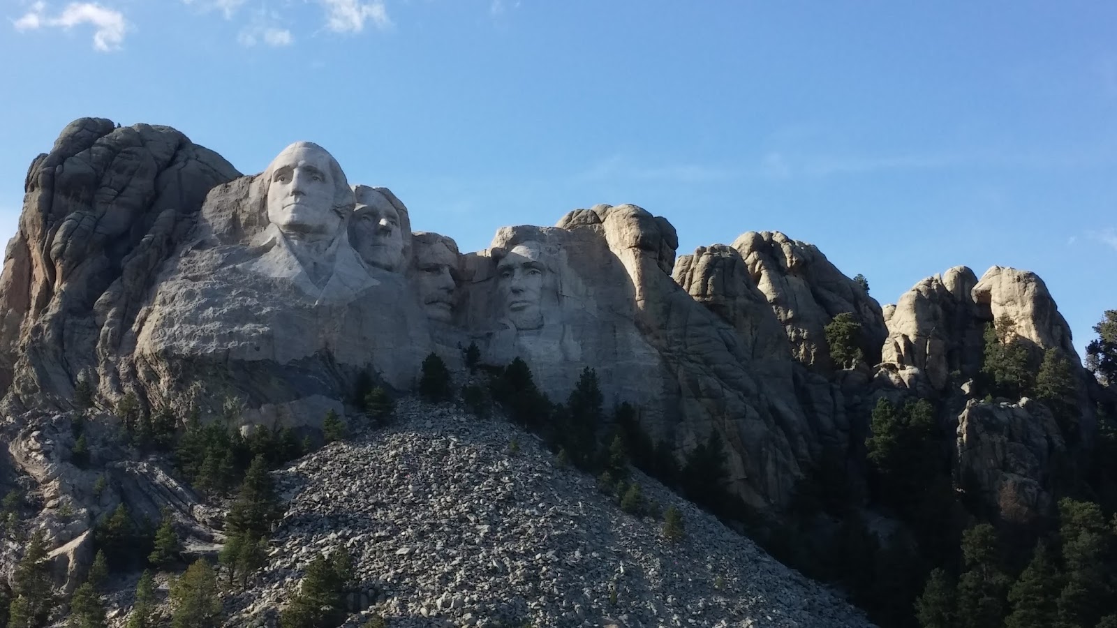
completed. Lincoln’s was dedicated on September 17, 1938.

The position of the Roosevelt bust needed to be between Jefferson and Lincoln, but Borglum wasn’t sure there was enough surface for sculpting. After blasting away 120 feet of granite, suitable stone was uncovered and the bust was dedicated on July 2, 1939.

Gutzon Borglum died in March 1941, with the project incomplete. The figures were supposed to be from the waist up but funding dried up and Borglum’s son oversaw the scaled back finishing.

Before Borglum’s death he had said the monument would be there “until the wind and rain alone shall wear them away”.

In the end, 400,000 + tons of rock was blasted away with a final cost of $989,992.32

More importantly, in the 14 years of blasting and sculpting, absolutely no lives were lost.

Dirk and I messed up by not realizing there was an exhibit area until about 30 minutes before it closed so we had to hurriedly go through and I’m sure we missed a lot. Maybe we’ll get back there some day.

One of the notes that I had made during the trip really should have been included in the “Missouri Here I Come” blog. It’s a new game I call “Deer Dodge”. You know the signs we’ve all seen…Deer Crossing…I’ve always wondered what I would do if one actually crossed.

My first experience with it was back in June when Dirk and I were coming back from St. Louis. A deer jumped on to the freeway in front of us. Thankfully, there was only us and one other car nearby. The other car ducked in behind me…oh sure, let me hit the darn thing. I slowed WAY down and it finally trotted off.

So in all these years, that is the only deer I’ve seen on a highway…until now. From about ½ way through Wyoming, we’ve seen the occasional deer on the side of the road. Yes, alive. Then last night, after we left the Oregon Trail Ruts, we had to slow to a crawl because a few deer in the road. Then tonight, after leaving Mt. Rushmore, I’ve seen many deer on the road or near the road. Nothing like a deer passing in front of you to raise your heart rate and make you pay much closer attention to the road at dusk and nightfall.

I really never want a story to start with…remember that deer I hit?

Monday, October 26, 2015

Victory & Lincoln Highways...West Wendover, Nevada


DATE:  October 6, 2015

SITE:  Victory & Lincoln Highways

LOCATION:  West Wendover Blvd., West Wendover, Elko Co., Nevada  89883

There were two plaques placed here. It seems the more significant of the two is for the Victory Highway but I recognized the other much more…the Lincoln Highway.

The plaque for the Victory Highway states…

“The Victory Highway monument is a representation of the earlier county bronze eagle markers of the 1920’s. Original eagle markers were to be located at each county line with a plaque dedicated to the sons and daughters who served their country in World War I, sacrificing their lives for our freedom. Only five original bronze eagles are knows to be in existence, two in Kansas and three in California. The Victory Highway is a near-forgotten relic of the early 20th century roadways, a path traversed by early auto-pioneers from the Atlantic to the Pacific Oceans. The road you are standing on today was completed in 1925 and used until the 1940’s. Highway U.S. 40 replaced the Victory Highway to the south, which is now known as Wendover Boulevard. The arch represents the Victory Highway sign, used at the only documented official ceremony opening the Victory Highway. The ceremony took place on June 25, 1925, just east of Wendover on the Bonneville Salt Flats. Officiating were Utah Governor George Dern, Nevada Governor James Scrugham, and Secretary of Agriculture William Jardine.”

“The Victory Highway Association was incorporated in Topeka, Kansas, late in 1921 to locate and mark a transcontinental highway. Victory Highway, dedicated to American Forces who died in World War I, traversed the United States from New York City to San Francisco. In 1925, the Transcontinental route offered a panorama of the mid-section of the country 3,205 miles, this great motorway follows the same course, or one closely parallels, as that of the earliest settlers of the Ohio, Mississippi, and Missouri valleys, crossing 14 states in all. Less than 14 percent or 788 miles of the highway was unimproved.”

“From Salt Lake City, the Victory Highway skirts around Great Salt Lake over the famous Wendover Cutoff. The crossing of the salt flats between Salt Lake City and Wendover on the Utah/Nevada border was costly, involving five years of labor. The remarkable engineering feat bridged what was once a great obstacle to transcontinental motor travel, the Bonneville Salt Flats. This accomplishment blazed a new auto-route across northern Nevada to Reno, parallel to the Lincoln Highway to the south. In the early mid-twenties, only 81 miles of the 371 miles of the Victory Highway across Utah were paved, 107 miles consisted of gravel surfacing, and 183 miles were relatively unimproved. The Victory Highway was designated Route No. 40 by state and federal highway officials shortly after the Wendover Cutoff was completed, and the Victory Highway was used until it was replaced in the 1940’s.”

“An original culvert to the east of this marker still exists today. When a new portion of Highway 40 was constructed in the 1940’s, this section of the Victory Highway, along with the culverts, was left intact. Constructed of stone and galvanized steel, these culverts are a testament to the skills of road engineers and rock masons of the early 19th century.”

“In 1921, the federal government passed the Federal Highway Act of 1921. A similar act, passed in 1916, provided matching funds to the states for highway construction. Unlike the 1916 act, the 1921 act required the states to identify seven percent of its total mileage as “primary”; only these roads would be eligible for federal funds. In the ten years prior to the 1921 act, the United States went from having one named highway to having an unorganized and confusing system of multiple-named highways. As a result, a numbered highway system was formed to organize the national highways across the United States. In most states, the Lincoln Highway was the obvious choice as a federal road, but there were a few exceptions, the greatest challenge being Utah. Despite numerous reports and heavy lobbying by the Lincoln Highway Association, the federal government selected the Wendover route or “Victory Highway” (Route No. 40) as the federal road across Utah and Nevada.”

The plaque for the Lincoln Highway states…

“In 1912, roads were dirt, bumpy and dusty in dry weather; impassable in wet weather. Asphalt and concrete roads were yet to come. To get from coast-to-coast, it was much easier to take the train. The Lincoln Highway Association conceived the first improved automobile road across the United States of America. Inspired by the Good Roads Movement, the Lincoln Highway ran from Times Square in New York City to Lincoln Park in San Francisco, traversing 14 states; New York, New Jersey, Pennsylvania, West Virginia, Ohio, Indiana, Illinois, Iowa, Nebraska, Colorado, Wyoming, Utah, Nevada, and California. This paved the way for the development of a nationwide highway network that is now unsurpassed. As the first automobile road across America, the Lincoln Highway brought great prosperity to hundreds of cities, town and villages along the way. The first officially recorded mileage in 1913 was 3,389 miles; by 1924 the road was improved and realigned, covering only 3,142 miles. A road was “improved” if it was just graded; few even had gravel in the early years of the association. One of the hardest fought realignments took place in the deserts of Utah, west of Sal Lake City. A new route, the Goodyear Cutoff, was surveyed, and prepared for construction by the Lincoln Highway Association. The Utah State government promoted a route directly west of Salt Lake City to Wendover, Nevada, as the route to San Francisco. This course crossed miles of salt desert, which was often submerged under water. The Wendover road, favored by Utah, was part of another named highway, the Victory Highway. Like the Lincoln, it claimed New York and San Francisco as its endpoints. Northern Californians favored the Victory for economic reason; travelers along the Victory would almost certainly end their trips in San Francisco.”

“Lincoln Highway Markers   The association ceased activity at the end of 1927. Its last major activity was to mark the highway not as a route from one destination to another, but as a memorial to President Abraham Lincoln, the roads namesake. On September 1, 1928, thousands of boy scouts fanned out along the highway. At an average of about one monument per mile, 3,000 concrete markers were installed with a small bust of Lincoln and the inscription, “This highway dedicated to Abraham Lincoln” were placed along the road from New York City to San Francisco.”

PERSONAL REFLECTIONS:

I found an old magazine on Google Books from 1922 that the president of the Victory Highway Association had written an article in. Being me, I couldn’t stay with just that article but perused several months’ worth. Interesting reading about many of the roads and the problems, some that were overcome, some just noted while building the road system in the U.S. and it has great pictures. It’s amazing what those first roads were like with some totally impassable at different times of the year. Roads could be paved in some fashion but most were more rudimentary than that. Work on the roads varied too. In some places, there might be one or two “government” workers; while many times locals who wanted roads to go by their town or place of business might get out there and “make” a road.

I liked this line from one of the magazines…”the contrast in roads typifies the contrast in social and economic standing of communities. The roads are the barometers of civilization”

The plan for the Victory Highway was to build a road from New York to San Francisco, using only roads already improved or likely to be improved within a short time frame. As I said before, road quality really varied. While investigating the best route, there was no real decisions to be made going from New York City to St. Charles, Missouri where the road was paved except for a tiny section of gravel road in New Jersey.

The first hurdle to deal with was the sticky mud of Missouri and then Kansas which had little to no paving. Colorado was in good shape with gravel along the route and California had the best roads of all. Although the route picked by the association from the state line to Sacramento was not paved, it was scheduled to be completed in a short timeframe.

The big problems were Utah and Nevada where travel was difficult through the desert and the route was often no more than a track in the sand to follow. For 3 months out of the year, the route in Utah is covered in water for about 40 miles. There were discussions over the best way to get over the salt flats with the idea of a raised road winning out.

This was the first time in history that one state helped another state finance projects. By 1922, cities in Northern California raised $50,000.00 to finance the building of the Wendover Cutoff. Fifteen years later, California also financed part of the highway through Nevada.  Not being shortsighted, California understood what it meant to get tourists to the state.

Numbered highways were introduced in 1926 and The Victory Highway Association continued to promote tourism. With the decline in “named” highways, the Association itself changed its name to U.S. Highway 40 Association.

As for the Lincoln Highway, I was pleased to see the reference to it since I came upon another one of the markers when I was exploring in the Newcastle area near home. Again, it’s interesting how things seen in one place link themselves to other places I visit.

There were huge political arguments over the best route…Victory vs. Lincoln with some of the decisions having to wait for politicians to be defeated or for the weather to finally teach developers a lesson. Some big names threw themselves behind one side or another…the Goodyear Tire & Rubber Company gave $75,000 for a cutoff to be built south of Wendover while the city of San Francisco threw their weight into a northern route; that being the Victory Highway.

When the possibility of federal funding came, both plans were to be presented but when the plan was submitted, only the northern route, Victory Highway. Despite protests from the Lincoln Highway group, the U.S. Bureau of Roads approved the northern route and funding was secured.

Today, neither highway in known except as part of history although both roads exist as part of U.S. Route 40.