DATE: 04/01/2016
HISTORICAL
SITE: Wagon Mound
LOCATION: East of Wagon Mound on U.S. 85, Mora County, New
Mexico
MARKER #: 66000478
DEDICATED: October 10, 1966
 “This last great landmark on the Santa Fe Trail was named for
its resemblance to the top of a covered wagon. At Wagon Mound, travelers could
cross from the Cimarron Cutoff to Fort Union, which is located on the Mountain
Branch of the Trail. The two branches joined south of here at Watrous.”
“This last great landmark on the Santa Fe Trail was named for
its resemblance to the top of a covered wagon. At Wagon Mound, travelers could
cross from the Cimarron Cutoff to Fort Union, which is located on the Mountain
Branch of the Trail. The two branches joined south of here at Watrous.”
PERSONAL
REFLECTIONS:
Traveling north on I-25 from Santa Fe, there really isn’t a
lot to look at. The landscape, a glimpse of what was to come for several days,
was mainly open grassland. As I promised
myself during my very first trip, my gas gauge showed a quarter tank so it was
time to start looking for a gas station. Then here comes this tiny little town
called Wagon Mound and, oh, good…gas. In fact, it’s not even legally a “town” but rather a “village”.

The village of Wagon Mound used to be quite prosperous and
then the interstate was put in and traffic just sped by…not unlike the story of
Route 66.
In 1900, the town boasted it had 4 saloons, a bank, a livery
barn, 3 bakeries, 2 grocery stores, 2 hotels, 2 blacksmith shops, 2
restaurants, and a weekly newspaper in both English and Spanish.
The main line of the Atchison, Topeka and Santa Fe Railway
went right through the town.
Pulling off the freeway, we see a sign for a historic site…bonus.
So, we fill our tank and then come back to the marker.
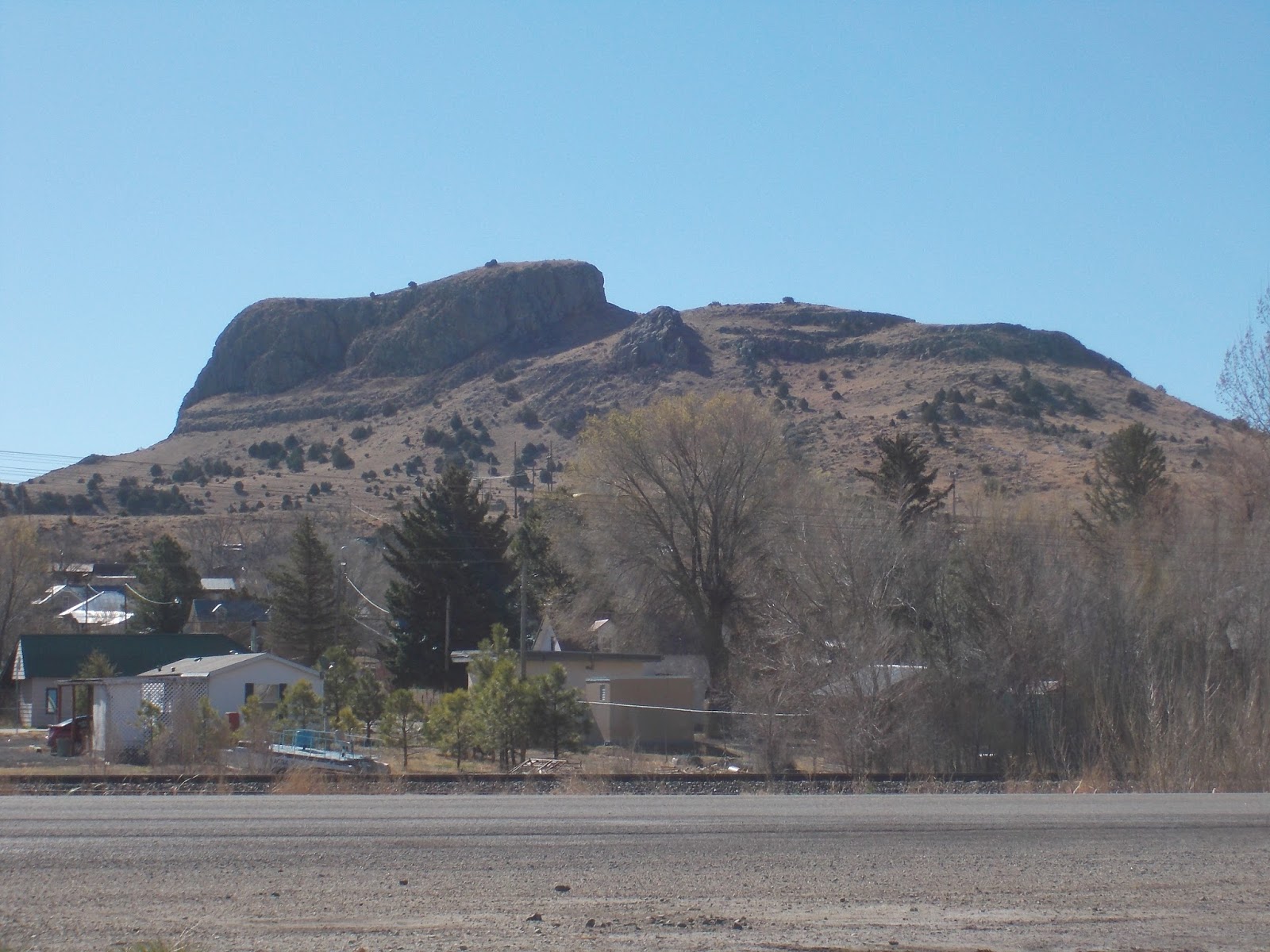
Wagon Mound, a large hill near the town, so named because it
looks like the top of a covered wagon is considered the “last great natural
landmark on the Santa Fe Trail” and can be seen at least 60 miles from the
North and East.

The Santa Fe Trail, which Wagon Mound is a part of, was one of
America’s great trading routes. A total of 1,200 miles from Franklin, Missouri
to Santa Fe, New Mexico, it was a vital trail for trading, the military and
emigrants from 1821 to 1880.
The trail had many Way Stations, Trading Posts and military
Forts.
Even after the territory was ceded by Mexico after the war, trade
between Mexico, south of the trail, and the United States flourished for many
years.
All along the trail, travelers used natural landscape features
to help them navigate. Places like Pawnee Rock, Rabbit Ears Mountain and Wagon
Mound aided the travelers.
 As you can imagine, Wagon
Mound, being 6,930 feet high, and resembling oxen pulling a wagon, was very
easy to see. Care needed to be taken to recognize this site as the area was the
Cimarron Cutoff point to Fort Union.
As you can imagine, Wagon
Mound, being 6,930 feet high, and resembling oxen pulling a wagon, was very
easy to see. Care needed to be taken to recognize this site as the area was the
Cimarron Cutoff point to Fort Union.
The area quickly became
a favored spot for travelers to rest. The abundance of green grass and water
was appealing, yet just 2 miles north, the Santa Clara Spring camping spot
became the site of many Indian ambushes.
The mound was not only
a navigational tool and a promise of a good rest, but became a warning to
travelers about the local Indians.
As the number of
travelers grew, the relationship with the Indians got worse as their
traditional way of life was interrupted more and more. This area had been home
to many major tribes including Comanche, Kiowa, Cheyenne, Arapaho, Plains
Apache, Osage, Kansas (Kaw), Apache, Ute, and Pueblo Indian.
 The U.S. Government,
along with Mexico, started providing escorts on the trail further enraging the
Indians until the “Mail Train Massacre” in May of 1850 where a mail train going
west was attacked and all 10 men were killed. The bodies weren’t found for a
couple of weeks until the eastern mail train came upon them.
The U.S. Government,
along with Mexico, started providing escorts on the trail further enraging the
Indians until the “Mail Train Massacre” in May of 1850 where a mail train going
west was attacked and all 10 men were killed. The bodies weren’t found for a
couple of weeks until the eastern mail train came upon them.
It was estimated there
were over 100 Indians and up until this point, a train with 10 men were
considered safe. The Government increased its raids and attacks against the
Indians; resulting in the Indian population being pushed back and onto
reservations.
During the civil war,
with the U.S. Army engaged elsewhere, the cutoff was considered too dangerous
with Confederate raiders and Indians so traffic basically stopped until the war
was over.
 And once the railroad
made its way through the area, the trail, given time, was abandoned for the new
transportation option.
And once the railroad
made its way through the area, the trail, given time, was abandoned for the new
transportation option.
Good read
ReplyDelete